Implementing Radius-Based Location Search for Dynamics 365
In field sales and service operations, time is one of the most valuable resources. A sales representative may have some free hours while traveling between meetings, while a service technician might lose valuable time when an appointment gets cancelled. When this happens, finding the next nearby opportunity can significantly improve productivity.
Radius-based location search comes in handy in such situations.
Radius search allows users to locate CRM records that exist within a defined geographic distance or travel time from a specific location. Instead of scanning through lists of accounts or leads, users can visualize nearby records directly on a map and quickly decide where to go next.
In Microsoft Dynamics 365, Power Apps, Power Pages, and Dataverse, this capability can be implemented using geo-mapping solutions such as Maplytics. With location intelligence integrated into CRM, businesses can transform their address data into actionable insights.
This blog explains how radius-based search works, why it is important, and how organizations can implement it effectively within their CRM environment.
Why Radius Search Matters in CRM Systems?
Many organizations store thousands of customer records inside their CRM. These records often contain address information, but that data is rarely used for geographic analysis.
Without mapping tools, sales teams typically search records using filters, lists, or reports. While these methods help identify customers based on industry, revenue, or status, they do not provide any information about physical proximity.
For field teams, proximity is critical.
A salesperson may already be in a particular area for a meeting. If another potential customer is located nearby, visiting them could lead to an additional opportunity without extra travel.
Radius search solves this problem by enabling users to locate customers, prospects, or service requests within a specific distance from their current location or a selected point on the map.
This simple capability can significantly improve field productivity.
Understanding Radius-Based Location Search
Radius search works by identifying all CRM records that fall within a defined circular area around a reference location.
The process typically involves three components:
- Current Location – The starting point of the search. This could be the user’s current GPS location, a customer’s address, or a manually entered location.
- Search Radius – The distance or travel time that defines the search boundary.
- Filtered Records – CRM records whose geographic coordinates fall inside the selected radius.
When the search is executed, the system plots all matching records on the map. Users can then analyze the results and take further actions, such as planning visits or scheduling meetings.
Types of Radius Searches in Dynamics 365
Radius search can be performed in multiple ways depending on the requirement. Modern mapping tools support several variations of proximity search.
Distance-Based Search
Distance-based radius search is the simplest form of proximity search.
In this method, the user specifies a fixed distance, such as 2 miles or 5 kilometers. The system then displays all CRM records located within that circular boundary around the chosen location.
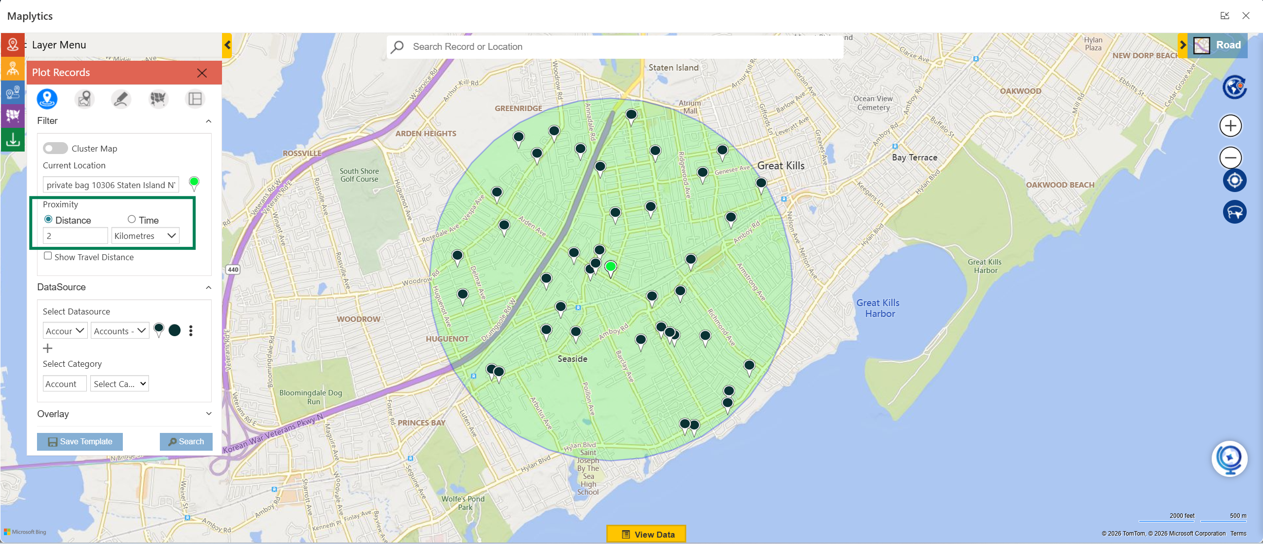
For example, a sales representative in Chicago might search for accounts within a 3-mile radius. The system immediately plots all nearby prospects, allowing the representative to plan additional visits during the same trip.
This approach is useful when users want a quick understanding of nearby opportunities.
Time-Based Search
While distance search is helpful, it does not always reflect real-world travel conditions. Traffic congestion, road networks, and travel restrictions can affect how long it takes to reach a destination.
Time-based radius search addresses this challenge.
Instead of specifying a distance, users define a travel time, such as 20 or 30 minutes. The system then calculates which CRM records can realistically be reached within that time frame.
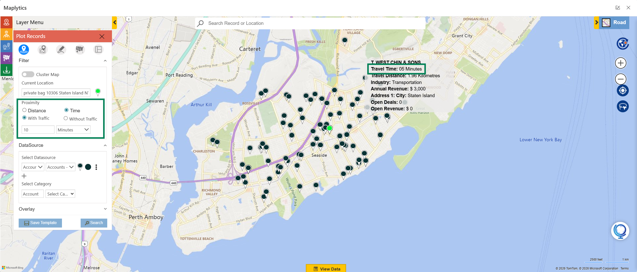
This calculation considers road networks and traffic patterns, helping users identify locations that are actually reachable within the specified time.
For example, a service engineer may have 45 minutes available before their next appointment. By performing a time-based search, they can locate nearby service calls that can be completed within that available window.
Concentric Radius Search
In some situations, organizations need a deeper understanding of customer distribution across different geographic regions.
This is where concentric radius search becomes useful.
Instead of defining a single radius, users can create multiple search zones, such as 2 km, 4 km, and 6 km. These zones appear as layered circles on the map.
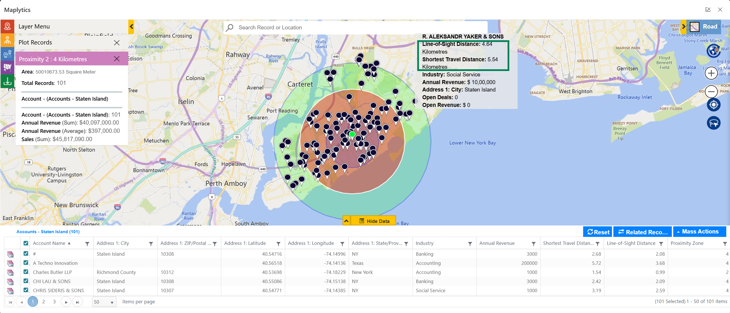
Each layer represents a different distance band, allowing users to analyze how many customers exist within each range.
For example, a sales manager planning a territory expansion may want to understand how many potential customers exist within different distances from a central location.
Concentric search makes it easier to prioritize outreach efforts based on proximity.
How Radius Search Works in Dynamics 365 with Mapping Tools
To implement radius-based search in Dynamics 365, mapping tools like Maplytics integrate directly with CRM records.
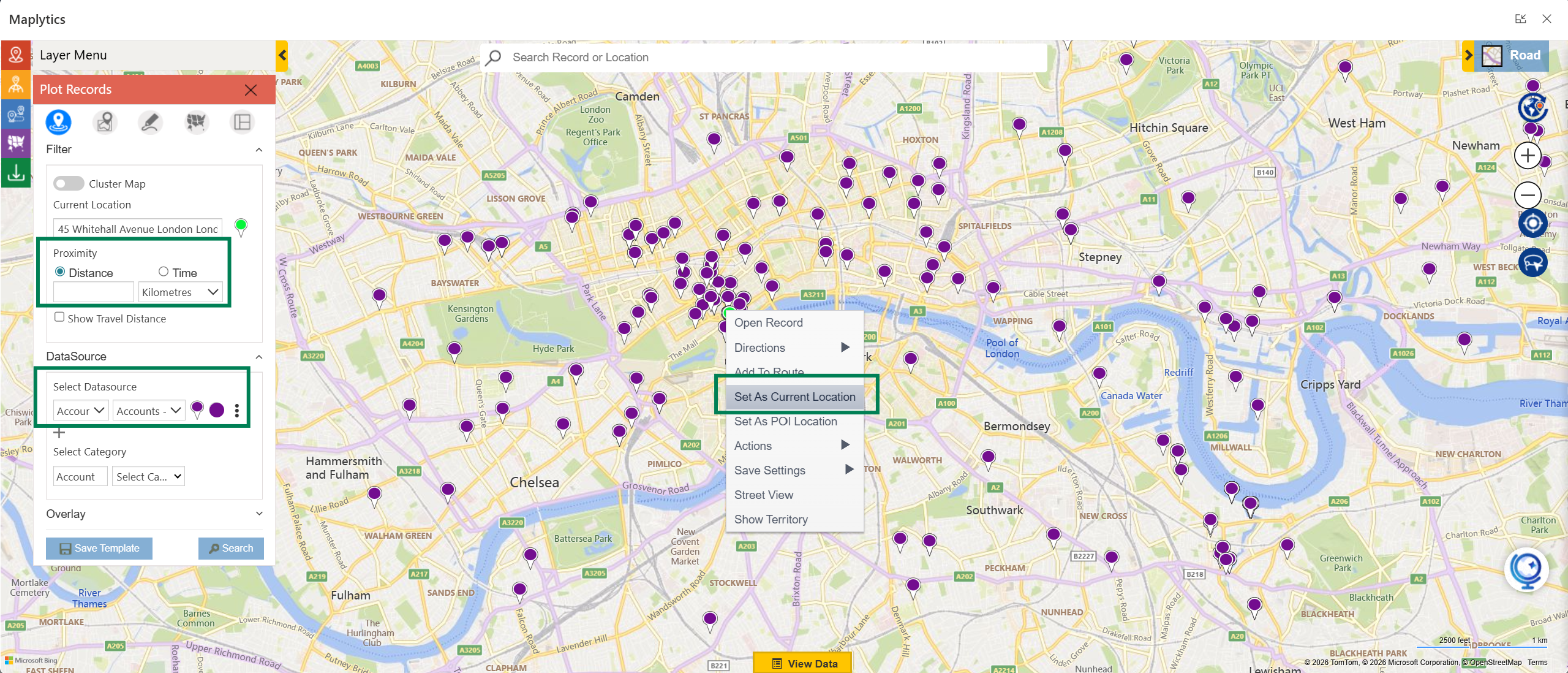
The typical workflow includes the following steps.
- First, the user opens the map interface within Dynamics 365. The map displays CRM records such as accounts, leads, or opportunities.
- Next, the user selects a reference location. This could be the user’s current location, a selected CRM record, or an address entered manually.
- After selecting the reference point, the user chooses the type of search to perform. The options generally include distance-based search, time-based search, or concentric radius search.
- Once the search parameters are defined, the system processes the request and plots all matching records on the map.
- Each record appears as a pushpin that represents its geographic location. Users can click these pushpins to view customer details, contact information, or opportunity data.
- From this point, users can take further actions such as scheduling meetings, planning routes, or navigating to the selected location.
Applications of Radius Search
Radius-based location search supports several real-world business scenarios.
Handling Cancelled Meetings
In field sales, cancelled meetings are common. Without a backup plan, this situation results in lost time.
By performing a radius search, the sales representative can quickly identify nearby prospects and schedule an alternative meeting within minutes.
Increasing Daily Customer Visits
Travel time often limits how many customers a field representative can meet in a day.
By identifying customers located close to one another, radius search helps users cluster meetings geographically and reduce unnecessary travel.
Improving Field Service Efficiency
For service teams, urgent requests often appear unexpectedly.
Using radius search, dispatchers can locate technicians with the required skills who are already near the customer’s location and assign the job accordingly.
This improves response times and enhances customer satisfaction.
Combining Radius Search with Other Location Intelligence Tools
Radius search becomes even more powerful when combined with additional mapping features.
For example, route optimization can determine the most efficient sequence of visits once nearby customers have been identified.
Territory management tools can help distribute accounts across regions based on geographic density.
Heat maps can reveal clusters of high-value customers, helping managers decide where to focus their resources.
When these capabilities are integrated with CRM, organizations gain a complete view of their geographic data.
Let’s Sum Up!
Location plays an important role in many business decisions, especially for organizations that depend on field teams. Radius-based location search allows companies to use geographic data stored in their CRM systems to improve productivity, reduce travel time, and discover new opportunities.
By implementing radius search in Dynamics 365 with tools like Maplytics, businesses can visualize customer locations, identify nearby prospects, and plan field activities more effectively. Instead of relying only on lists and filters, teams can now see their data on a map and make faster, more informed decisions.
And in field operations, those faster decisions often translate directly into better results!
What’s More?
Maplytics, with its features, is available for Dynamics 365, Power Apps, Power Pages, and Dataverse. Organizations interested in adoption, 15-day free trials, or personalized demos are encouraged to contact Maplytics’ sales team at [email protected]
Happy Mapping!