Introducing MapCopilot — The AI-Powered Mapping Assistant for Dynamics 365
In the world of modern CRM, maps and data don’t just coexist but collaborate. Enter MapCopilot, the newest addition to the Maplytics suite, built expressly for Dynamics 365 and Dataverse users who demand spatial intelligence at the speed of thought. Instead of running complex queries, toggling filters, and re-plotting, you ask a simple, natural-language question. MapCopilot turns it into a visual map, routing plan, or spatial insight instantly.
Whether you’re plotting locations, performing proximity searches, optimizing routes, or uncovering nearby points of interest, MapCopilot brings intelligence to your fingertips. Ready to navigate your CRM with a whole new level of precision?
Why It Matters
Traditional mapping workflows inside Dynamics 365 often require multiple manual steps. Selecting an entity, applying filters, choosing map layers, configuring push-pins, and more. These steps cost time and introduce friction. MapCopilot simplifies this by:
- Reducing clicks and configuration: Type “Show active accounts within 10 miles of Chicago” and get results plotted instantly.
- Bridging AI + Mapping: Your prompts are interpreted and transformed into queries, enabling even less technical users to tap into spatial analysis.
- Embedding in the CRM workflow: The assistant runs entirely within Maplytics inside Dynamics 365, so users don’t need to leave their familiar interface. If your field teams, sales reps, or service operators spend too much time navigating or chasing data, MapCopilot changes the game.
Core Capabilities
1. Natural-Language Prompts for Mapping Actions
With MapCopilot, mapping becomes conversational. You type or speak what you need.
Example prompts:
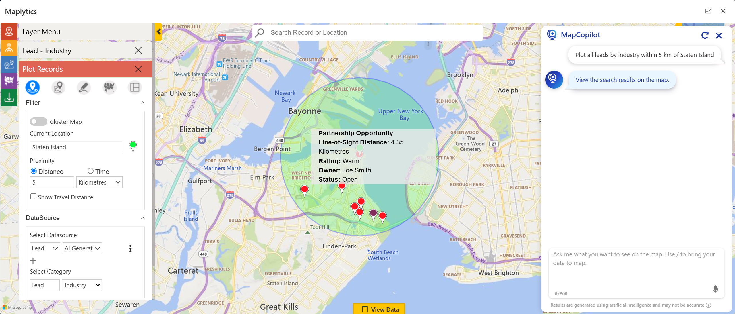
- “Plot all leads by industry within 5 km of Staten Island”
- “Optimize route for these five work orders for tomorrow.”
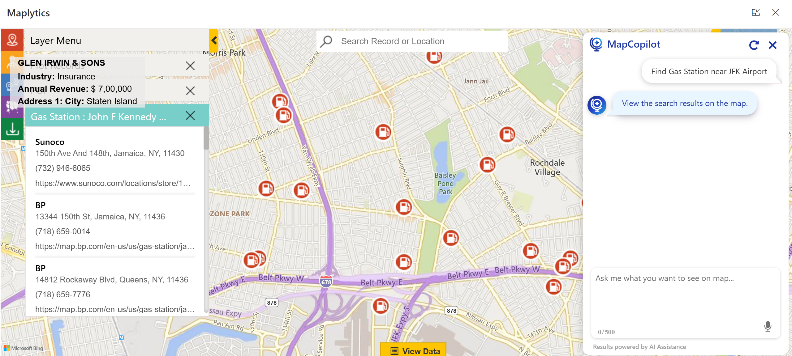
- “Find gas stations near H. JOHN & SONS.”
This ease lets you serve spatial insight rapidly and intuitively.
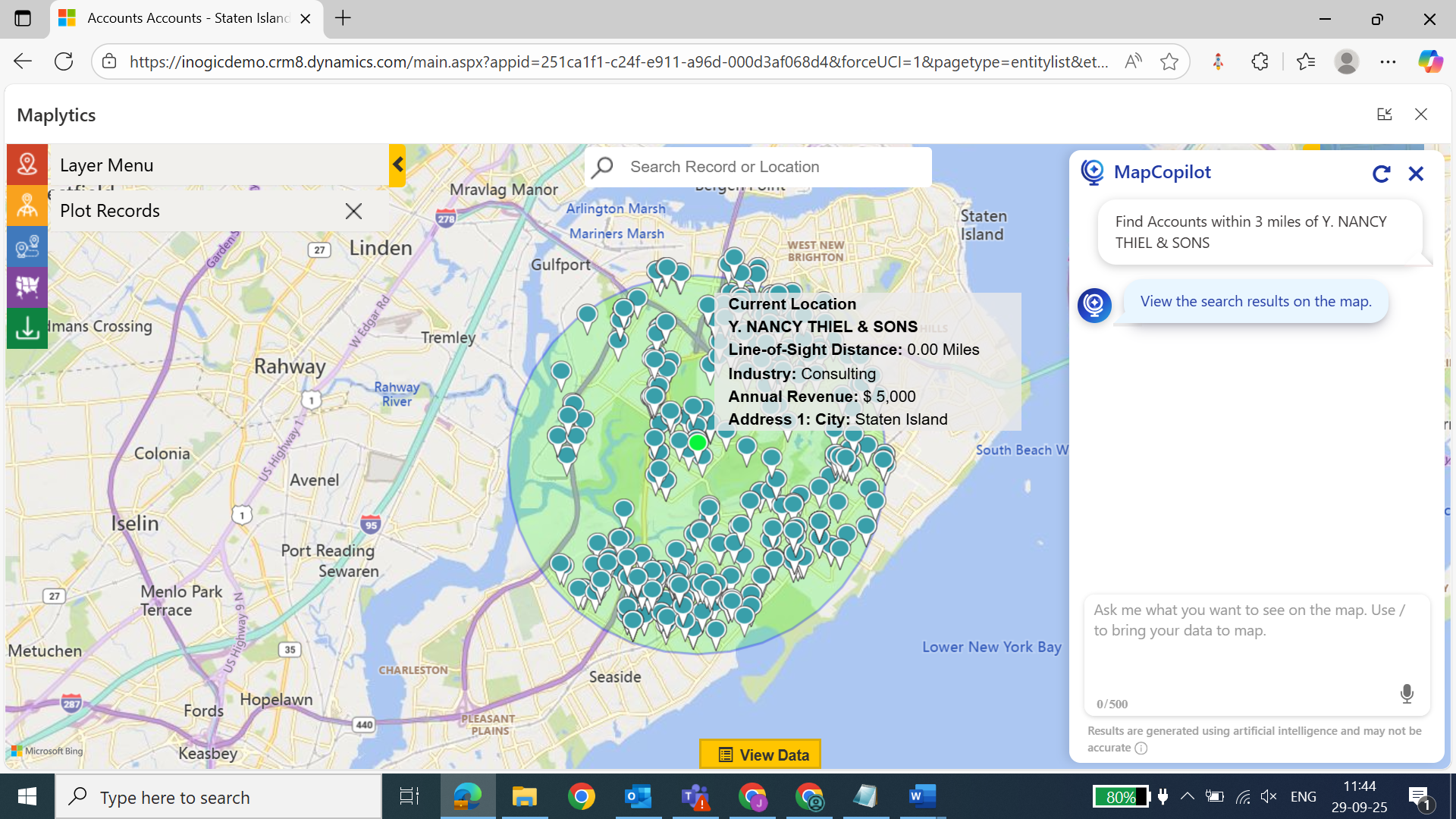
2. Proximity & Radius Search Made Simple
Ask for nearby records without manually specifying location, radius, or entities. For example: “Show accounts within 3 miles of account Y. NANCY THIEL & SONS.” MapCopilot translates that into a radius search, plots results, and visualizes distance/travel time.
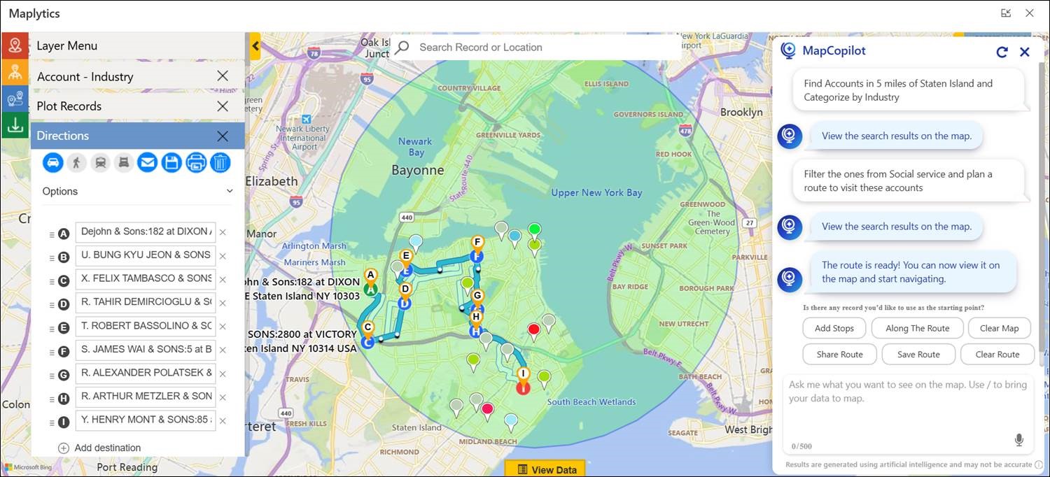
3. Route Optimization Built In
Planning multiple field stops? Provide your waypoints via prompt, and MapCopilot computes the most efficient travel route. It considers stop sequence, travel conditions, and location logic. This results in fewer miles, more visits, and greater productivity.
4. Points-of-Interest (POI) & External Data Support
Beyond CRM records, MapCopilot helps you locate your next Point Of Interest (gas stations, cafés, airports). Plot external spreadsheet or file-based data without importing into CRM. This feature turns raw lists or partner data into actionable maps.
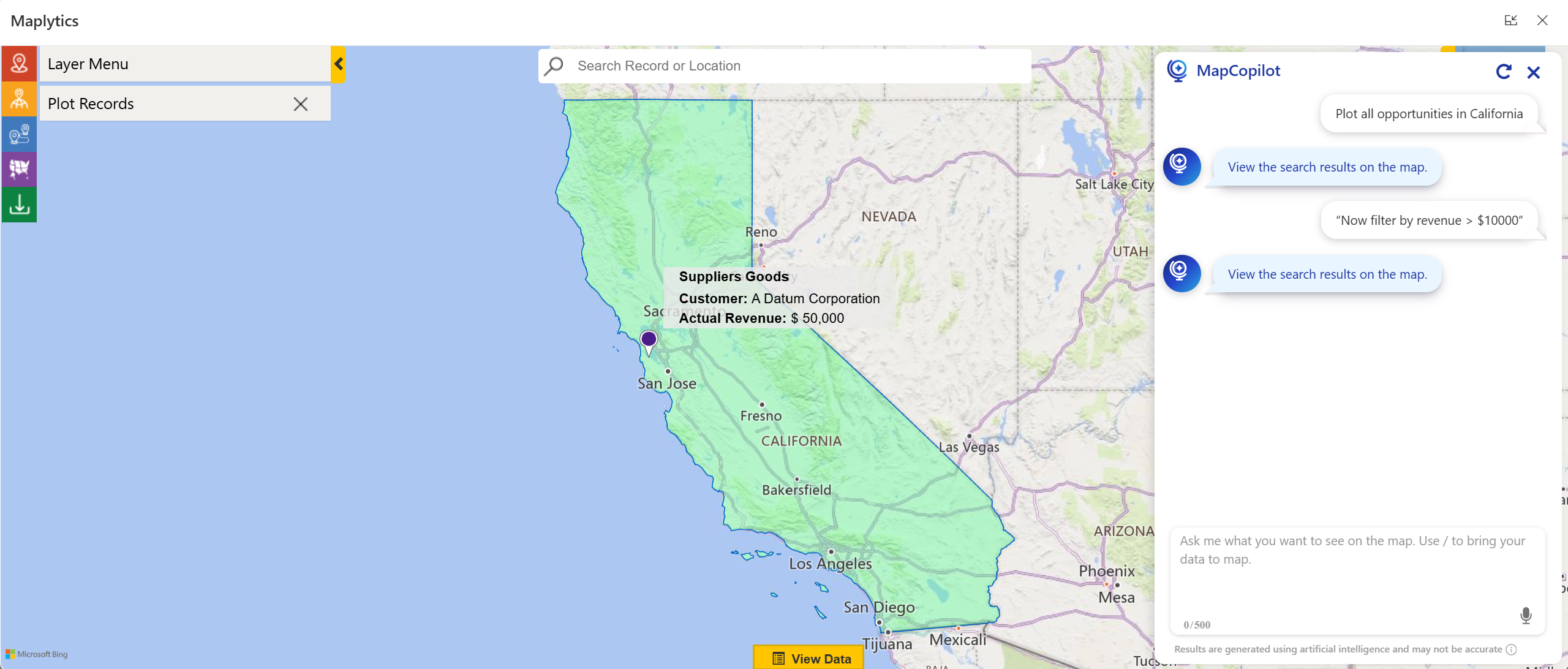
5. Context-Aware Conversational Session
MapCopilot retains context across your prompts. Start with one action-
“Plot all opportunities in California”
and refine in the same session
“Now filter by revenue > $10000”
The assistant remembers the previous state and applies it accordingly.
Technical Integration & Architecture
MapCopilot builds on Maplytics’ robust mapping engine and integrates with Maps under the hood. It is delivered as a part of the Maplytics package for Dynamics 365 and Dataverse. Key architectural highlights:
- Accessible via the Maplytics interface inside Dynamics 365; no external tool needed.
- Leverages the map panels for high-performance rendering on desktop and mobile.
From initial setup, importing the Maplytics solution, to trial usage, the configuration remains streamlined. Users can begin plotting, visualizing, and querying within minutes.
Workflow Examples & Enterprise Value
Scenario: Field Sales Team Planning
A sales manager can easily show all open service leads within 50 km of his warehouse, categorized by priority, and optimize the route for field reps’ visits.” MapCopilot plots the leads, categorizes them, and recommends the optimal travel sequence. This leads to more visits, less drive time, and elevated productivity.
Organizations using Maplytics have reported transportation cost savings of up to 20%, route-time reductions of 30%, and faster decision-making using map visualizations.
Why MapCopilot Matters to You?
- Democratizes spatial intelligence – No GIS experience necessary.
- Speeds up decision-making – Simple commands create visual outcomes.
- Transforms CRM workflows – Location becomes a first-class attribute across entities.
- Optimizes field operations – More efficient routing, higher visit count, lower cost.
- Scales easily – Works across regions, mobile devices, and enterprise-grade deployments.
Ready to Explore?
MapCopilot is now available as part of Maplytics for Dynamics 365 and Dataverse. Whether you’re embarking on your location-intelligence journey or ready to upgrade your mapping capabilities, this is the moment to step into smarter CRM workflows.
Get started with your free trial today and discover how AI-assisted maps change your team’s outlook and act upon data.
To get more acquainted and experience Maplytics first-hand, one can write to [email protected].
We can arrange a personalized free demo for your requirements. You can also enjoy a 15-day free trial in your environment.
For applied knowledge, visit our Website or Microsoft AppSource. One can hop onto the detailed Blogs, Client Testimonials, Success Stories, Industry Applications, and Video Library for a quick query resolution. Technical docs for the working of Maplytics are also available for reference.
Kindly leave us a review or write about your experience on AppSource or the G2 Website.