ESRI ArcGIS Meets Microsoft Dynamics 365 CRM- A Smarter Map for Smarter Decisions
Imagine you are a regional sales director for a national retail chain, sitting in front of two screens. On the left is your CRM, customer profiles, purchase histories, sales territories, and open deals. On the right is your GIS platform, zoning boundaries, population density maps, competitor locations, and demographic overlays.
Both screens are full of valuable information. Neither screen can talk to the other. Every decision you make requires switching between them, copying data across, and hoping the context you lose in translation does not cost you a deal.
This is not an unusual situation. It is the daily reality for sales managers, field service teams, logistics coordinators, and operations leaders who rely on both CRM data and geographic intelligence to do their jobs well. The data exists. The insight does not.
Well, at least not until both sets of information are visible in the same place, simultaneously.
That is the gap Maplytics offers to close by integrating ESRI's ArcGIS Online with Microsoft Dynamics 365 CRM!
Story One: How can a Utility Company Plan a Quick Maintenance Rollout?
Meet Pam. She manages field operations for a mid-sized utility company responsible for electricity infrastructure across a busy urban region. Her team runs on Dynamics 365. Every customer interaction, service request, complaint, and technician schedule lives there. Meanwhile, the company's engineering division maintains a detailed ArcGIS environment populated with geographical data, including transformer locations, high-voltage corridor maps, weather risk zones, and underground cable networks.
For years, Pam's operational planning relied on a frustrating ritual. She would pull a customer complaint list from Dynamics 365, then cross-reference it manually with GIS maps to check for proximity to high-risk infrastructure. One screen, then the other. Notes on a notepad. Decisions were made with incomplete visibility and a quiet sense that something important was probably being missed.
After integrating ArcGIS with Dynamics 365 through Maplytics, Pam opened her CRM one morning and saw her entire operational picture on a single map. Live ArcGIS feature layer, transformer locations, power line corridors, and weather alerts sit directly on top of her CRM data, now. Customer addresses, complaint clusters, service territories, and technician routes are all visible alongside the infrastructure context, making those details meaningful.
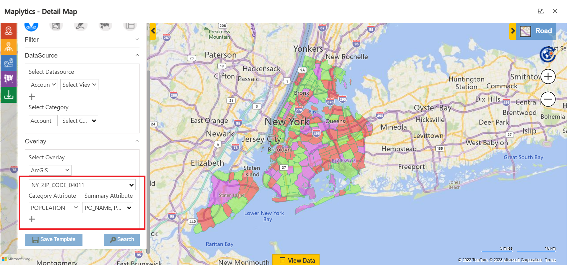
In a single view, Pam’s field teams could now see:
- Customer addresses and the precise locations of reported faults
- Proximity to high-voltage zones and underground infrastructure
- Defined service territories and optimized technician routes
- Real-time weather risk overlays affecting specific areas
Service visits could be planned with both urgency and safety in mind, directly inside Dynamics 365, without a single tab switch. Smarter, automated scheduling, safer, optimized routing, and faster resolution within Dynamics 365. All from the same screen Pam was already working on.
Story Two: How a Retail Manager Plans an Expansion?
Now meet Daniel. He is a retail expansion manager for a growing consumer brand, tasked with identifying the best locations to open three new stores across the Midwest over the next eighteen months. His company uses Dynamics 365 to manage customer profiles, regional sales data, and area-based purchase trends. The data tells him who is buying and where, but not why certain neighbourhoods outperform others, or where the whitespace is that competitors have not yet noticed.
That context lives in ArcGIS. Population density breakdowns by ZIP code. Competitor store locations and their estimated catchment areas. Traffic flow data and footfall patterns. Commercial real estate activity and zoning classifications. Rich, layered geographic intelligence, sitting entirely outside Daniel's CRM and therefore almost entirely unused in his planning process.
With Maplytics connecting both platforms, Daniel could open a sales territory inside Dynamics 365 and immediately see the ArcGIS layers that made that territory make sense. Demographic overlays appeared alongside customer purchase data. Income distribution heat maps sat next to sales performance figures. Competitor positions showed up on the same map as Daniel's own account clusters.
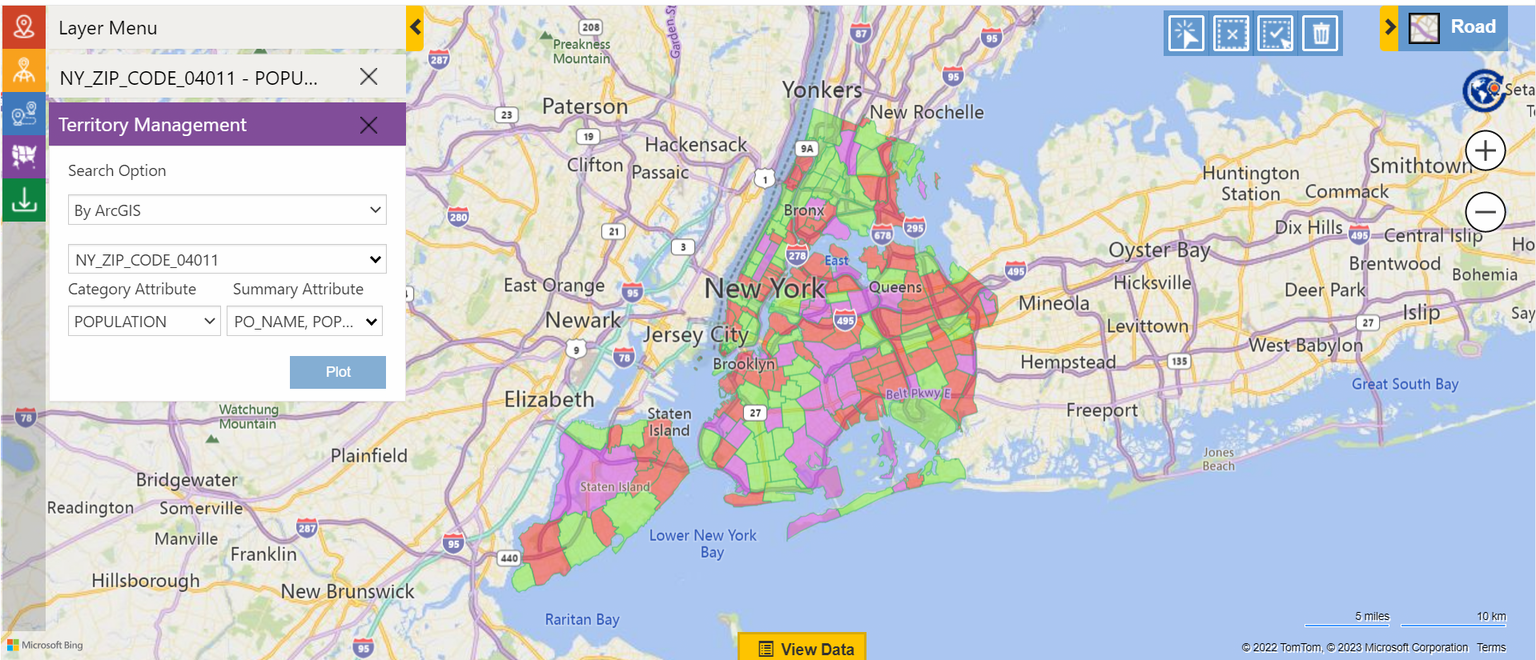
No switching between tools. No losing context mid-analysis. No re-explaining the geography to a colleague who only had the CRM view. Just a single, complete picture that made expansion decisions faster, sharper, and considerably more defensible in a boardroom.
What Does the Maplytics and ArcGIS Integration Actually Enable?
The stories of Pam and Daniel illustrate the same underlying truth- ‘when GIS data and CRM data exist in separate systems, they are both less useful than they should be. The integration changes fundamentally.’ Here is what it enables in practice.
Live ArcGIS Layers Inside Your CRM Map
ArcGIS feature layers with flood zones, zoning maps, distribution networks, and infrastructure grids can be overlaid directly onto your Dynamics 365 map through Maplytics. These are not static screenshots or exported files. They are live layers. When something changes in ArcGIS, it updates in Dynamics 365 automatically. Your CRM map always reflects the current geographic reality.
Territories Built on Real Geography
Sales territory planning has always suffered from the gap between administrative boundaries and actual geography. With ArcGIS boundaries, postal codes, counties, electoral districts, and natural terrain features feeding directly into Maplytics' Territory Management, your sales zones finally reflect the way the world is actually shaped. Assignments become more balanced, coverage becomes more logical, and the perpetual argument about who owns which postcode largely disappears.
Deeper Analysis, Same Screen
Customer behaviour, sales performance, and service history can now be analysed alongside GIS data in a single view. Previously invisible patterns, a cluster of high-value customers consistently appearing near a specific geographic feature, or a service territory that underperforms because of a natural boundary nobody had mapped, become obvious when both data sets share the same canvas.
Field Teams Deployed with Full Spatial Context
Rather than dispatching field teams based purely on customer records and inbound requests, operations managers can now direct people based on live map data. Infrastructure conditions, risk zones, access constraints, and proximity information are all visible at the point of decision. The result is faster deployment, safer routing, and fewer surprises on site.
Who Benefits Most from This Integration?
The answer is broader than most people expect. Any team that makes decisions based on both customer data and locational context stands to gain significantly.
- Sales Managers planning regional outreach, realigning territories, or identifying expansion opportunities
- Field Service Teams coordinating routes, responding to urgent requests, and managing site visits against infrastructure constraints
- Marketing Teams designing location-based campaigns that reflect actual demographic and geographic reality
- Operations Teams planning asset deployment, managing infrastructure rollouts, or evaluating business expansion options
Beyond these core teams, the integration opens up meaningful possibilities for logistics managers routing delivery fleets, non-profit organisations mapping their service reach and donor distribution, and healthcare providers analysing coverage gaps against population health data. Anywhere that addresses and data points benefit from being understood in their physical context, this integration adds value.
And because the entire setup runs within Microsoft's secure ecosystem, the data that moves between ArcGIS and Dynamics 365 stays protected, synchronised, and governed by the same permissions and policies your organisation already has in place.
Two Platforms, One Picture
Pam still uses two platforms, but she no longer works across two worlds. Daniel still has more data than he can act on, but now it all appears in one place, in a form he can actually use. The integration does not simplify the complexity of their work. It makes that complexity visible, navigable, and actionable.
That is what Maplytics' integration of ESRI ArcGIS with Dynamics 365 ultimately delivers. Not just a connected map, but a connected way of working. One where your CRM data and your geographic intelligence finally speak the same language, and help you make decisions you could not have made before.
What's More?
Maplytics adapts to the shape of your business. Whether your mapping needs run on Bing Maps, Azure Maps, Google Maps, Apple Maps, or ESRI ArcGIS, Maplytics makes the integration inside Dynamics 365 feel seamless, from Radius Search and Route Mapping to Territory Management and Heat Map analysis, etc. To experience it first-hand, you can have a 15-day free trial of get a personalised demo inside Microsoft Dynamics 365 CRM, Power Apps, Power Pages, or Dataverse, get in touch at [email protected], or explore more at the Website and Microsoft Marketplace.